Example Report
|
The emailed reports contain weather information and advisories selected by the farmer. The email is purposefully simple with few images so that it will quickly download for farmers with slow internet connections. The example below contains a real report for a specific date and location. In addition to the weather information and management advisories, it lists the reports which are not in season and which the subscriber has chosen not to receive.
April 12, 2020
Horizon Point Report for Farmer Jones' Home Place
|
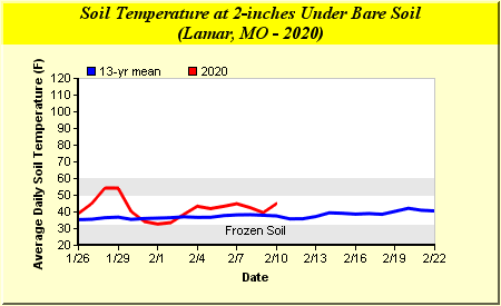
Spring Planting Soil Temperature Chart
| |
|
Soil temperature, not air temperature, controls germination of seeds. Soil temperature needs to be above 50°F for corn to germinate and 60°F for soybeans to germinate. Optimum temperatures for germination are higher.
Click [ here ] to view a table of 2-inch soil temperatures from other Missouri locations.
Please let us know if you have any trouble viewing this chart by sending a message to
HorizonPoint@missouri.edu.
All comments regarding this chart or the use of graphics in your report are welcome and desired.
|
Horizon Point Weed Scouting Aid
This information should be used as a general guide to aid in weed scouting and weed
management decisions. These calculations are based on the ambient air degree days
accumulated since January 1. Additional factors, such as the soil type, amount of
rainfall received, and the presence of crop residue will have a significant impact
on the likelihood of weed emergence in a given situation.
The following weeds could have emerged in your area recently:
|
|
Pennsylvania smartweed,
Common sunflower,
Giant ragweed,
Common lambsquarters,
Giant foxtail,
Common ragweed,
Velvetleaf,
Woolly cupgrass |
| |
| The following weeds could be emerging in your area by the date given. |
| |
|
|
Alfalfa Weevil
Calculations based on growing degree days. |
| Stage of Development |
Date |
| Egg |
4/6/2020 |
| 1st Instar |
4/12/2020 |
| 2nd Instar* |
4/15/2020 |
| 3rd Instar |
4/21/2020 |
| 4th Instar |
4/29/2020 |
| Pupa |
5/14/2020 |
* Begin scouting on second instar.
|
| Precipitation Information |
| | Historical | | Forecast |
| | 04/08 | 04/09 | 04/10 | 04/11 | 04/12 | 04/13 | 04/14 | 04/15 |
| Probability (%) | - | - | - | - | 0 | 0 | 4 | 6 |
| Lamar | 0.00 | 0.00 | 0.00 | 0.00 | - | - | - | - |
| NWS | 0.00 | 0.00 | 0.00 | 0.00 | 0.00 | 0.00 | 0.00 | 0.42 |
| User Provided | na | na | na | na | - | - | - | - |
| |
| Temperature Information |
| | Historical | | Forecast |
| | 04/08 | 04/09 | 04/10 | 04/11 | 04/12 | 04/13 | 04/14 | 04/15 |
| Air Max (ºF) | 62 | 72 | 76 | 78 | 80 | 81 | 80 | 80 |
| Air Min (ºF) | 37 | 40 | 48 | 47 | 55 | 58 | 57 | 59 |
| Soil Temp 2" (ºF) | 57 | 57 | 58 | 62 | - | - | - | - |
| Rainfall Index Monitor - PRF Gridpoint 22651 |
| | Rainfall (in.) | Current Interval Est. |
| Gridpoint Interval | 04/07 | 04/08 | 04/09 | 04/10 | 04/11 | Accum | Avg | Index |
| Jan-Feb | | | | | | 2.1 | 3.8 | 57.3 |
| Feb-Mar | | | | | | 5.7 | 5.0 | 114.0 |
| Mar-Apr | 0.02 | 0.08 | 0.0 | 0.63 | 0.0 | 4.4 | 6.9 | 63.4 |
| Apr-May | 0.02 | 0.08 | 0.0 | 0.63 | 0.0 | 2.0 | 8.7 | 22.9 |
| May-Jun | | | | | | | 9.3 | |
| Jun-Jul | | | | | | | 8.2 | |
| Jul-Aug | | | | | | | 7.7 | |
| Aug-Sep | | | | | | | 7.5 | |
| Sep-Oct | | | | | | | 7.1 | |
| Oct-Nov | | | | | | | 5.8 | |
| Nov-Dec | | | | | | | 4.6 | |
|
The Rainfall Index Monitor report is designed to assist understanding the rainfall index used to calculate indemnities paid through the Pasture, Rangeland and Forage (PRF) Insurance program. PRF Insurance is administered through the USDA Risk Management Agency (RMA).
The rainfall index is based on data from the National Oceanic and Atmospheric Administration (NOAA) Climate Prediction Center (CPC) that is specific to grid locations. Each grid area is 0.25 degrees in latitude by 0.25 degrees in longitude. The rainfall index is interpolated from data from multiple weather stations by the CPC.
It is important to note that daily CPC rainfall reported for Missouri covers a 24 hour time period of 7:00 a.m. to 7:00 a.m., during daylight savings time (6:00 a.m. to 6:00 during standard time). If you check your rain gauge in the morning, you will be able to closely monitor any differences between your measurements at home and interpolated data provided by NOAA.
Under the Current Interval Estimates heading, there are three items reported. Accum is the accumulated precipitation during the selected two month period for a specific grid point in the PRF program. Avg is the long term average for the same two month period and grid point. Those two numbers are used to calculate the Index number. At the end of the intervals time period, the Index should be the same index number used by RMA to calculate indemnities for those signed up for PRF insurance.
|
| Wind Forecast (mph): * |
| Time | 04/12 | 04/13 | 04/14 |
| 12:00 AM | - | 10 S | 12 SSE |
| 3:00 AM | - | 9 S | 12 SSE |
| 6:00 AM | 7 SSE | 9 SSE | 10 S |
| 9:00 AM | 10 S | 15 S | 15 S |
| 12:00 PM | 14 S | 17 S | 17 S |
| 3:00 PM | 15 S | 15 S | 14 S |
| 6:00 PM | 9 S | 12 SSE | 9 S |
| 9:00 PM | 9 SSE | 12 SSE | - |
| * ie: 10 N = 10 mph wind blowing from north. |
Est. Rainfall Needed for Runoff
(Soil Category: Very Slow Infiltration Soil) |
| | 04/12 | 04/13 | 04/14 |
| Bare Soil | 0.30 | 0.30 | 0.30 |
| Row Crop - Conservation practices in place. | 1.12 | 1.12 | 1.12 |
| Row Crop - Without conservation practices. | 0.47 | 0.47 | 0.47 |
| Hay | 1.34 | 1.34 | 1.34 |
| Pasture (Cool Season) - Good condition. | 1.19 | 1.19 | 1.19 |
| Pasture (Cool Season) - Poor condition. | 0.59 | 0.59 | 0.59 |
| Pasture (Warm Season) - Good condition. | 1.19 | 1.19 | 1.19 |
| Pasture (Warm Season) - Poor condition. | 0.59 | 0.59 | 0.59 |
| Cattle Heat Stress Index |
| Time |
4/12/2020
| 4/13/2020 | 4/14/2020 |
| 1:00 AM | - | Comfort | Comfort |
| 4:00 AM | - | Comfort | Comfort |
| 7:00 AM | Comfort | Comfort | Comfort |
| 10:00 AM | Comfort | Comfort | Comfort |
| 1:00 PM | Comfort | Comfort | Comfort |
| 4:00 PM | Comfort | Danger | Comfort |
| 7:00 PM | Comfort | Comfort | Comfort |
| 10:00 PM | Comfort | Comfort | - |
| Design Storm Report |
| Design Storm | Dates | Estimated
Precipitation* (in) | Design Storm
Value (in) | % of Design
Storm Value | County Status** |
| 25-yr/24-hr | 12/22/16 | 0.0 | 5.8 | 0 | Clear |
| 10-yr/10-day | 12/13/16 - 12/22/16 | 0.1 | 8.1 | 1 | Clear |
| 10-yr/90-day | 9/24/16 - 12/22/16 | 4.3 | 23.4 | 18 | Clear |
| 10-yr/180-day | 6/26/16 - 12/22/16 | 25.3 | 35.6 | 71 | Clear |
| 10-yr/365-day | 12/24/15 - 12/22/16 | 41.7 | 49.5 | 84 | Watch |
* Radar estimate for grid point closest to your location using NOAA Daily Precipitation Analysis
** County Status may be different than indicated by your gridpoint % of Design Storm Value. For more information:
- Design Storm Alert System
- Design Storm Map Viewer
|
| vegetable |
minimum
temp |
optimum range
minimum temp |
optimum
temp |
optimum range
maximum temp |
maximum
temp |
| Asparagus |
50 |
60 |
75 |
85 |
95 |
| Bean |
60 |
60 |
80 |
85 |
95 |
| LimaBean |
60 |
65 |
85 |
85 |
85 |
| Beet |
40 |
50 |
85 |
85 |
85 |
| Cabbage |
40 |
45 |
85 |
95 |
100 |
| Carrot |
40 |
45 |
80 |
85 |
95 |
| Cauliflower |
40 |
45 |
80 |
85 |
100 |
| Celery |
40 |
60 |
70 |
70 |
85 |
| SwissChard |
40 |
50 |
85 |
85 |
95 |
| Corn |
50 |
60 |
95 |
95 |
105 |
| Cucumber |
60 |
60 |
95 |
95 |
105 |
| Eggplant |
60 |
75 |
85 |
90 |
95 |
| Lettuce |
35 |
40 |
75 |
80 |
85 |
| Muskmelon |
60 |
75 |
90 |
95 |
100 |
| Okra |
60 |
70 |
95 |
95 |
105 |
| Onion |
35 |
50 |
75 |
95 |
95 |
| Parsley |
40 |
50 |
75 |
85 |
90 |
| Parsnip |
35 |
50 |
65 |
70 |
85 |
| Pea |
40 |
40 |
75 |
75 |
85 |
| Pepper |
60 |
65 |
85 |
95 |
95 |
| Pumpkin |
60 |
70 |
90 |
90 |
100 |
| Radish |
40 |
45 |
85 |
90 |
95 |
| Spinach |
35 |
45 |
70 |
75 |
85 |
| Squash |
60 |
70 |
95 |
95 |
100 |
| Tomato |
50 |
70 |
85 |
95 |
95 |
| Turnip |
40 |
60 |
85 |
105 |
105 |
| Watermelon |
60 |
70 |
95 |
95 |
105 |
Key: |
| | Soil temperature is within the optimum range |
| | Soil temperature is outside of the optimum range but within the minimum to maximum range |
| | Soil temperature is outside of the minimum to maximum range |
* for more information go to agebb.missouri.edu/horizonpoint/vegseedgerm.htm
University of Missouri Extension - AgEBB
|
|
You have selected to include the following reports but they are unavailable for 04/12/2020.
Click the report title for additional information and/or an example of the report.
Grain Drying
Black Cutworm (BCW) Alert
Black Cutworm Capture
True Armyworm Capture
Fall nitrogen application chart
The following reports are being generated for this location but are not currently selected for viewing.
Click the report title for additional information and/or an example of the report.
Poultry stress index
University of Missouri Extension
Commercial Agriculture Program
MU Integrated Pest Management
MU AgEBB
North Central Risk Management Education Center |
For more information about the Horizon Point system,
contact us at 573-882-4827 or
HorizonPoint@missouri.edu