
Portageville, Missouri
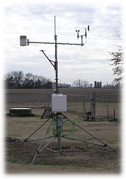
Fisher Delta Research Center, Pemiscot
Online - July 18, 2026, 12:15 am CDT
Fisher Delta Research Center is currently down.
Data is currently unavailable due to technical difficulties. We are currently working on getting this issue fixed. We apologize for the inconvenience.
Current Conditions (updated every 5 minutes)
Summary
Time:
12:01 am
5:28 pm
Time:
12:13 am
6:15 am
Time:
12:10 am
6:56 pm
Pemiscot County Forecast
Tonight:
Mostly clear. Lows in the mid 70s. Southwest winds around 5 mph.
Saturday:
Sunny. A slight chance of showers and thunderstorms in the afternoon. Humid with highs in the lower 90s. West winds 5 to 10 mph. Chance of rain 20 percent. Heat index values up to 105.
Saturday Night:
Mostly clear. Lows in the mid 70s. West winds 5 to 10 mph.
Sunday:
Sunny. A chance of showers and thunderstorms in the afternoon. Humid with highs in the lower 90s. West winds around 5 mph. Chance of rain 50 percent. Heat index values up to 107.
¹ Since midnight | ² Ice or snow not recorded | ³ Short crop | * Bare Soil
More info about the station