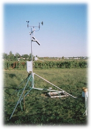

Mountain Grove, Missouri
Mountain Grove, Wright
Online - August 1, 2026, 11:00 pm CDT
Close
Mountain Grove is currently down.
Data is currently unavailable due to technical difficulties. We are currently working on getting this issue fixed. We apologize for the inconvenience.
Current Conditions (updated every 5 minutes)
Temperature:
Dew Point:
Humidity:
Today's Precipitation:¹²
Wind Speed:
Peak Wind Gust:
Wind Dir:
NW
Baro. Pressure:
29.91 in. ↔
Summary
Today:¹
Yesterday:
Max Temp:
Time:
Time:
72.5°F
12:07 am
12:07 am
88.0°F
5:03 pm
5:03 pm
Min Temp:
Time:
Time:
65.2°F
9:10 am
9:10 am
71.7°F
7:01 am
7:01 am
Precipitation:²
0.06 in.
0.25 in.
Peak Wind Gusts:
Time:
Time:
27.8 MPH
9:31 am
9:31 am
18.9 MPH
9:15 pm
9:15 pm
Estimated ET:³
0.14 in.
Avg Soil 2 Temp:*
84.0°F
Sunrise:
Sunset:
Wright County Forecast
Rest Of Tonight:
Mostly cloudy. Areas of drizzle early, then patchy drizzle. Humid. Near steady temperature in the mid 60s. Northwest winds 10 to 15 mph. Gusts up to 30 mph.
Sunday:
Mostly sunny. Warmer with highs in the lower 80s. North winds 10 to 15 mph with gusts up to 30 mph.
Sunday Night:
Mostly clear. Humid with lows in the lower 60s. North winds 5 to 10 mph with gusts up to 20 mph in the evening, becoming light and variable.
Monday:
Sunny, hot with highs in the mid 80s. Northeast winds around 5 mph.
¹ Since midnight | ² Ice or snow not recorded | ³ Short crop | * Bare Soil
More info about the station