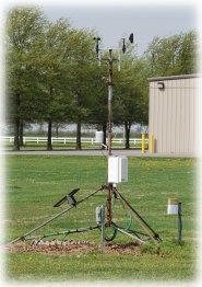
Hayward, Missouri

Lee Farm, Pemiscot

Online - May 15, 2025, 9:15 pm CDT
More Information
Close

Lee Farm is currently down.

Data is currently unavailable due to technical difficulties. We are currently working on getting this issue fixed. We apologize for the inconvenience.

Current Conditions (updated every 5 minutes)

Temperature:
75.5°F
Dew Point:
68.9°F
Humidity:
80%
Today's Precipitation:¹²
0.03 in.
Wind Speed:
8.7 MPH
Peak Wind Gust:
13.9 MPH
Wind Dir:
S
Baro. Pressure:
29.74 in. ↓
More...

Summary

Today:¹
Yesterday:
Max Temp:
Time:
82.5°F
11:59 am
81.2°F
2:24 pm
Min Temp:
Time:
70.9°F
4:59 am
65.0°F
4:47 am
Precipitation:²
0.03 in.
0.00 in.
Peak Wind Gusts:
Time:
26.2 MPH
3:59 pm
15.5 MPH
9:01 am
Estimated ET:³
0.12 in.
Avg Soil 2 Temp:*
74.5°F

Sunrise:
5:51 am
Sunset:
7:58 pm
More...

Pemiscot County Forecast

Tonight:
Mostly cloudy with a chance of thunderstorms. A chance of showers this evening, then showers likely after midnight. Lows in the lower 70s. Southwest winds 10 to 15 mph. Chance of rain 70 percent.

Friday:
Partly sunny. A chance of showers with a slight chance of thunderstorms in the morning, then showers and thunderstorms likely in the afternoon. Breezy with highs in the mid 80s. Southwest winds 15 to 20 mph with gusts up to 30 mph. Chance of rain 70 percent.

Friday Night:
Mostly cloudy with showers and thunderstorms likely in the evening, then mostly clear after midnight. Breezy with lows in the upper 60s. Southwest winds 15 to 20 mph with gusts up to 30 mph, diminishing to around 10 mph after midnight. Chance of rain 70 percent.

Saturday:
Sunny. Highs in the mid 80s. West winds 10 to 15 mph.

More...
Missouri Climate Center forecast based on information obtained from the National Weather Service. For more information, please contact Dr. Pat Guinan at 573-882-5908.

¹ Since midnight | ² Ice or snow not recorded | ³ Short crop | * Bare Soil


More info about the station

Pemiscot County Forecast | As of Thu May 15, 2025 - 5:52 PM CDT


Tonight
Mostly cloudy with a chance of thunderstorms. A chance of showers this evening, then showers likely after midnight. Lows in the lower 70s. Southwest winds 10 to 15 mph. Chance of rain 70 percent.

Friday
Partly sunny. A chance of showers with a slight chance of thunderstorms in the morning, then showers and thunderstorms likely in the afternoon. Breezy with highs in the mid 80s. Southwest winds 15 to 20 mph with gusts up to 30 mph. Chance of rain 70 percent.

Friday Night
Mostly cloudy with showers and thunderstorms likely in the evening, then mostly clear after midnight. Breezy with lows in the upper 60s. Southwest winds 15 to 20 mph with gusts up to 30 mph, diminishing to around 10 mph after midnight. Chance of rain 70 percent.

Saturday
Sunny. Highs in the mid 80s. West winds 10 to 15 mph.

Saturday Night
Mostly cloudy. A chance of showers with a slight chance of thunderstorms after midnight. Lows in the mid 60s. Southwest winds around 5 mph, becoming southeast around 5 mph after midnight. Chance of rain 40 percent.

Sunday
Mostly cloudy with showers likely with a slight chance of thunderstorms in the morning, then partly sunny with a chance of showers and thunderstorms in the afternoon. Highs in the lower 80s. Chance of rain 60 percent.

Sunday Night
Mostly cloudy with a chance of thunderstorms. A chance of showers. Lows in the upper 60s. Chance of rain 50 percent.

Monday
Partly sunny. A chance of showers and thunderstorms, mainly in the morning. Highs in the mid 80s. Chance of rain 40 percent.

Monday Night
Mostly cloudy with a chance of showers and thunderstorms. Lows in the lower 70s. Chance of rain 40 percent.

Tuesday
Mostly cloudy in the morning, then becoming partly sunny. A chance of showers. A slight chance of thunderstorms in the morning, then a chance of thunderstorms in the afternoon. Breezy with highs in the mid 80s. Chance of rain 50 percent.

Tuesday Night
Mostly cloudy. Showers likely with a chance of thunderstorms in the evening, then a chance of showers with a slight chance of thunderstorms after midnight. Lows in the upper 60s. Chance of rain 60 percent.

Wednesday
Mostly sunny with a slight chance of showers and thunderstorms. Breezy with highs in the upper 70s. Chance of rain 20 percent.

Wednesday Night
Partly cloudy. Lows in the upper 50s.

Thursday
Mostly sunny. Highs in the mid 70s.

Hayward, Missouri

Lee Farm, Pemiscot


Summary
Yesterday - May 14, 2025

Max Temp:
Time:
81.2°F
2:24 pm
Min Temp:
Time:
65.0°F
4:47 am
Peak Wind Gust:
Time:
15.5 mph
9:01 am
Precipitation:
0.00 in.
Estimated ET:³
0.12 in.
Avg Soil 2 Temp:*
74.5°F
Avg Soil 4 Temp:*
72.1°F

¹ Since midnight | ² Ice or snow not recorded | ³ Short crop | * Bare Soil

Hayward, Missouri

Lee Farm, Pemiscot


Current Conditions | As of May 15, 2025, 9:15 pm

Temperature:
75.5°F
Dewpoint:
68.9°F
Humidity:
80%
Today's Precipitation:¹
0.03 in.
Wind Speed:
8.7 MPH
Peak Wind Gust:
13.9 MPH
Wind Dir.:
S
Baro. Pressure:
29.74 in. ↓
Solar Radiation:
0.034 W/m²

¹ Since midnight | ² Ice or snow not recorded

Hayward, Missouri

Lee Farm (Pemiscot) Weather Data Archive

Lee Farm weather station is part of the University of Missouri Extension
Commercial Agriculture Automated Weather Station Network