
AgEBB-MU CAFNR Extension
Green Horizons
Volume 21, Number 2
Spring 2017
FOREST HEALTH
The Grand River Basin Project: Hope for the Forests along Lower Locust Creek
By Ken McCarty | Missouri State Parks
Pershing State Park, in southern Linn County, is a wetland jewel possessing remnants of every riverine natural community type once native to north Missouri... a rare combination of 2,400 acres native bottomland forest, 600 acres of cordgrass prairie, intermixed by shrub swamp, slough, marsh and oxbow lakes through which an un-fettered Locust Creek meanders.
However, in recent years, large, park-wide swaths of these mature, bottomland hardwood trees are dead or dying. Forest understories that once modelled the historic richness of bottomland woodlands in grasses, sedges and wildflowers are barren mudflats or are covered in reed canary grass and disturbance-tolerant plants. The water is gone, and boardwalk panels from the 1990's describing the birds and amphibians in a natural slough now face a mud-bottomed, silver maple thicket. Seasonal shows of perennial wildflowers and sedges that once defined the park's wet prairies are now known only from photographs. As a result, the area was dropped from Missouri's registry of natural areas.
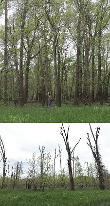 |
The narrowing and elimination of riparian forest buffers to provide more acreage for agriculture, and the straightening of streams in the Locust Creek watershed have caused increased flooding duration and magnitude resulting in the conversion of hard-mast pin oak forest (above) to lower quality silver maple and willow stands with a highly undesirable reed canary grass understory (below). |
These impacts are the result of changes on the landscape that began decades earlier. Meandering streams were straightened and channelized to improve drainage. Riparian corridors were narrowed to provide more acreage for agriculture. More water flowed over shorter distances with more energy resulting in severe erosion. Sediment and large woody debris swept down the system during high flow events. At the north end of the park, US 36 crosses the floodplain creating a pinch point when sediment and woody debris blocks Locust Creek creating avulsions that cut across the floodplain, flooding low-lying areas and depositing huge amounts of sediment.
Pershing State Park is just one example of the magnitude of this regional problem. The park is just one parcel in the sprawling 52,000-acre juncture of river floodplains where the Locust and East Yellow creeks join the Grand River in north Missouri. Those unusually broad river bottoms encompass 22,000 acres of natural and managed wetlands at Pershing State Park, Fountain Grove Conservation Area and Swan Lake National Wildlife Refuge, plus multiple private duck clubs and Wetland Reserve Program project sites.
What's being done? Missouri's Departments of Natural Resources and Conservation have teamed up with the Kansas City District, US Army Corps of Engineers in a major Grand River Basin Project. Over the next two years, a deep examination of the issues behind this ecosystem degradation and stream problems in the lower Grand will produce choices for engineering solutions, with the report being the essential precursor to authorization and funding of construction projects to resolve some of the underlying causes.
Those involved in the Lower Grand's lands and resources welcome this cooperative initiative towards solving the natural resource and farmland loss, stream bank erosion, infrastructure threats, flooding and log jams that continue to challenge this area. For the natural wetlands and forests in Pershing State Park, the hope remains for Locust Creek to resume its meanders through a recovering belt of bottomland hardwood forest and cordgrass prairie with sloughs, marshes and shrub swamps no longer stretched beyond their native resiliency by trapped backwaters, logjams, or feet-thick layers of new mud and silt.