Green Horizons
Volume 19, Number 3Fall 2015
Planning a Successful Timber Harvest
By: HANK STELZER | MU Forestry Extension
A successful timber harvest lies in working with a professional forester and your logger before the first tree is cut. The following abbreviation of a ten-step approach developed by Lynn Barnickol (Missouri Consulting Foresters Association) and Jason Jensen (Missouri Department of Conservation) provides an excellent framework for the planning process. Emphasis on each step may vary with site and location in Missouri.
- Safety first. Safety must remain a constant consideration throughout the harvest planning process. Every decision made will have safety implications.
- Recon. Using aerial, topographic and soil maps, your forester will conduct on-the-ground reconnaissance of the area to be logged. Noted are: the slope, aspect, soils, timber stands to be harvested, streams, access to the timber, boundaries, and old logging roads.
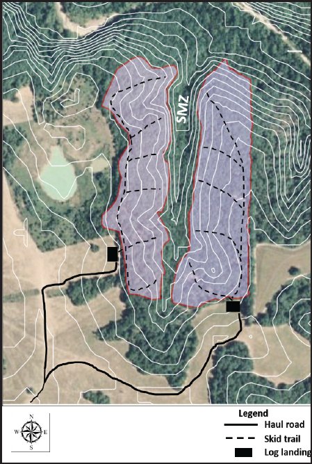
- Identify streamside management zones (SMZ's). SMZ width is site specific and is determined by factors such as stream classification, soil type, and percent slope. An SMZ should be a minimum of 50 feet wide or as determined in Missouri Watershed Protection Practice.
- Locate log decks. Location of the log decks depends on road building cost, skidding cost, timber volumes, skidder payload, and environmental impact. The size of the log deck will depend upon the type of logging equipment to be used, topographic constraints, landing layout, amount of timber skidded to the deck, and environmental impact. Log decks should be kept as small as feasible, be slightly sloped, facilitate drainage, and have stable soils that do not easily rut.
- Locate logging road entrances. In some areas, highway entrances must be approved by the resident highway engineer. Generally, the law requires 300 feet of visibility in either direction when pulling onto the highway. Truck turning radius, angle of approach, and direction of travel loaded and empty must be considered. Entrances should always be located on well-drained, stable soils and road rock may be needed to keep mud from being transferred onto the highway.
- Locate logging roads. New roads should be located on a topo map prior to locating on the ground. Your forester will take the map to the woods and flag-in the proposed road. Road grade should be kept at 8% or less and the roadbed placed on well-drained, stable soils. As a general rule, haul roads should be 1-« times as wide as the equipment utilizing the road, allowing the truck driver to address any ruts or soft places in the road. Harvesting trees adjacent to the road will improve drying and snow melt in the winter. Most primary haul roads are county roads. Secondary haul roads connect the harvest site to the county road or highway. Typically, secondary roads aren't graveled except for possible soft spots. Drainage can usually be handled through a few well-placed water turn-outs or broad-based dips. Your forester will consider cost, volume of timber to be hauled over the roads, time of year that the roads will be used, type of trucks using the roads, length of road to be built, available road construction equipment, the need for rock surfacing, time it will take to construct the roads, and how the road will be retired when harvesting is completed.
- Locate stream crossings. Stream crossings can be expensive, hard on equipment, and a source of environmental and water quality problems. If it is determined that a stream crossing is necessary, your forester will choose a location that will minimize the chance of stream sedimentation resulting from logging or hauling operations. The common types of stream crossings, from least to most expensive, are a ford, a culvert with dirt fill, a "low-water" bridge, and an elevated timber bridge. The "best" choice depends upon the cost, stream characteristics, amount of use anticipated, load bearing requirements, area of forestland drained by the stream, previous "high-water" mark, time of year the structure will be used, and environmental impact.
- Locate main skid trails. Properly located skid trails will minimize damage to the residual stand. Loggers can utilize undesirable trees as "bumpers" to prevent damage to higher quality crop trees. Main skid trails will also be located away from SMZ's or other sensitive areas and placed so they can be drained with water bars when harvesting is completed. A general rule of thumb is to keep skidding distance less than ¼ mile to maintain productivity and profitability.
- Determine the schedule of operations. The most efficient schedule of operations depends on the tract topography, time of year, current and anticipated weather conditions, road construction requirements, and cash flow.
- Specify tract "close-down" requirements. Included are: re-grading ruts, installing water bars on abandoned roads and skid trails, reseeding certain landings and roads, removing temporary stream crossing structures, cutting spring poles, slashing tops, removing trash, opening ditches or water turnouts, and any clean-up necessary to leave the tract in acceptable shape. To help reduce time and costs, many of the operations can be scheduled as harvesting is completed on various parts of the tract.
 |